
CHICKASAWHAY RIVER
check river levels
River levels change quickly due to rainfall and seasonal conditions. Always evaluate river conditions and your own paddling ability before launching.
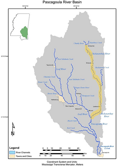
The Chickasawhay River is the second main contributary to the Pascagoula River. It has its origins just north of Enterprise, MS at the confluence of the Chunky River and the Okatibbee River and runs 210 miles until it joins the Leaf River near Merrill, MS to form the Pascagoula.
The Chick, as it is sometimes called, is navigable for its entire distance, limited only to the accessability of suitable landings. It meanders through mostly rural countryside while passing through a number of small historic towns that recognize its contribution to their history and survival with river festivals and events.
Unlike its sandy sister river, the Leaf, the Chick cuts through millions of years of rock and sediment, exposing millennia of fossils, and is consequently, famous among geologists for its prehistoric significance.
LANDINGS
HWY. 63 TO BUKATUNNA-CHICORA-CLARA RD.
CHICKASAWHAY RIVER
HWY. 63 (near Waynesboro, MS) to Bukatunna-Chicora-Clara Rd. (near Bukatunna, MS)
Launch – Hwy. 63 (Gravel and Dirt drive to concrete boat ramp)
Take Out - Bukatunna-Chicora-Clara Rd. (Gravel drive to concrete boat ramp)
Distance - 14 miles
Time - 5-7 hours
Points of Interest (in order) -
Patton Creek - @ mile 2.95 On Left
Meadows Mill Creek - @ mile 7.65 On Left
Bukatunna-Chicora-Clara Rd. Bridge at Take Out
Take Out on Right
Drive from Hattiesburg Train Station to Hwy. 63 Launch - 53 miles (1 hour)
Drive from Hwy. 63 Launch to Bukatunna-Chicora-Clara Rd. Landing - 12 miles (16 minutes)
Drive from Bukatunna-Chicora-Clara Rd. Landing to Hattiesburg Train Station - 57 miles (1.2 hours)
BUKATUNNA-CHICORA-CLARA RD. TO HWY. 42
CHICKASAWHAY RIVER
Bukatunna-Chicora-Clara Rd. (near Bukatunna, MS) to Hwy. 42 (near Stateline, MS)
Launch – Hwy. 63 (Gravel drive to concrete boat ramp)
Take Out - Hwy. 42 (Gravel and dirt drive to primative sandbar)
Distance - 16 miles
Time - 6-8 hours
Points of Interest (in order) -
Beaver Creek - @ mile 2.7 On Right
Bukatunna Creek - @ mile 6.7 On Left
Brewers Creek - @ mile 8 On Right
Big Creek - @ mile 9.5 On Right
Unnamed Stream - @ mile 13.8 On Left
Davis Creek - @ mile 15.76 On Left
Take Out On Left
Drive from Hattiesburg Train Station to Bukatunna-Chicora-Clara Rd. Launch - 57 miles (1.2 hours)
Drive from Bukatunna-Chicora-Clara Rd. Launch to Hwy. 42 Landing - 15 miles (17 minutes)
Drive Hwy. 42 Landing to Hattiesburg Train Station - 49 miles (1 hour)
HWY. 42 TO OLD AVERA ROAD
CHICKASAWHAY RIVER
HWY. 42 (near Stateline, MS) TO OLD AVERA RD.
Launch – Hwy. 42, Stateline, MS (Gravel and Dirt drive to primitive sandbar)
Take Out - Old Avera Rd. (Gravel drive to concrete boat ramp)
Distance - 6 miles
Time - 2-3 hours
Points of Interest (in order) -
Robertson Creek - @ mile 1.15 On Right
Snell Creek - @ mile 3.5 On Left
Johnson Creek - @ mile 5 On Left
Old Avera Bridge at Take Out
Take Out on Left
Drive from Hattiesburg Train Station to Hwy. 42 Launch - 49 miles (1 hour)
Drive from Hwy. 42 Launch to Old Avera Rd. Landing -5 miles (6 minutes)
Drive from Hwy. 42 Landing to Hattiesburg Train Station - 49 miles (1 hour)
OLD AVERA RD. TO LEAKESVILLE, MS
CHICKASAWHAY RIVER
OLD AVERA RD. TO LEAKESVILLE, MS
Launch – Old Avera Rd. (Gravel and drive to concrete boat ramp)
Take Out - River Street, Leakesville, MS (Paved parking and concrete boat ramp)
Distance - 23.15 miles
Time - 8-12 hours
Points of Interest (in order) -
Griffin Creek - @ mile 3 On Right
Morgan Mill Branch - @ mile 4.3 On Right
Byrd Creek - @ mile 9.5 On Left
Unnamed Stream - @ mile 11.9 On Left
Jones Creek - @ mile 11.34 On Right
Green Creek/Robertson Creek - @ mile 16.2 On Left
Fourmile Creek - @ mile 18.75 On Right
McCleod Creek - @ mile 19.82 On Left
Blakely Creek - @ mile 2.55 On Right
Hwy. 57 Bridge - @ mile 23.04
Take Out on Left
Drive from Hattiesburg Train Station to Old Avera Rd. Launch - 49 miles (65 minutes)
Drive from Old Avera Rd. Launch to River St., Leakesville Landing - 7 miles (23 minutes)
Drive from River St., Leakesville, MS Landing to Hattiesburg Train Station - 51 miles (1 hour)

LEAKESVILLE, MS TO MERRILL, MS
CHICKASAWHAY RIVER
LEAKESVILLE, MS TO MERRILL, MS
Launch – River Street, Leakesville, MS (Paved parking and concrete boat ramp)
Take Out - Ransom Jones Dr., Merrill, MS
Distance - 28.6 miles
Time -12-14 hours
Points of Interest (in order) -
Martin Creek - @ mile .9 On Right
Bukatunna Lake - @ mile 1.1 On Left
Faulk Ditch - @ mile 1.85 On Left
Maples Creek - @ mile 3.5 On Left
Roads Creek - @ mile 4 On Right
Sandy Creek - @ mile 4.23 On Left
Wooten Creek - @ mile 10.47 On Right
Crawford Creek - @ mile 13.9 On Right
Big Creek - @ mile 15.25 On Right
Evans Creek - @ mile 16.9 On Left
Skinner Creek - @ mile 18.9 On Left
Gatling Creek - @ mile 20.8 On Right
Hogan Creek - @ mile 23.9 On Right
McInnis Creek - @ mile 24.33 On Left
Confluence with Leaf River - @ mile 28.15
Main St. Merrill Bridge - @ mile 28.42
Take Out on Left
Drive from Hattiesburg Train Station to River St. Launch (Paved parking and concrete boat ramp) - 51 miles (1 hour)
Drive from River St. Launch to Ransom Jones, Dr. Landing - 24 miles (26 minutes)
Drive from Ransom Jones Dr. Landing to Hattiesburg Train Station - 56 miles (52 minutes)