

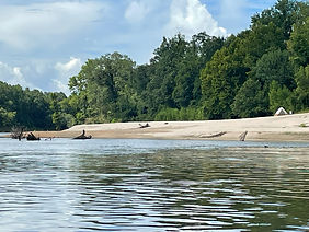
Video: Great Blue Heron launches at Tallahala between Hwy. 42 and Thomas Creek Rd.
Tallahala Creek has it's headwaters in the backwoods of Jasper County between Montrose and Rose Hill, MS. It meanders 120 miles until it empties into the Leaf River near Mahned, MS. It's name is generally thought to be derrived from the Choctaw words, tali and ahala, meaning rock and standing or "standing rock". We have paddled sections of it from the confluence of Tallahoma Creek, north of Tucker's Crossing Rd. at Ellisville to it's entry into the Leaf River. It appears navigable much farther upstream, but there may not be many established landings.
According to Herndon, the creek is navigable from Highway 29, east of Ellisville to the Moselle-Ovett Road, but is fraught with shallows and logjams. (Herndon, Canoing Mississippi (2001). Rivers frequently change, and we found it very navigable from Ellisville, with few problematic logjams in early 2026 in rather high water.
We have only paddled four sections of the creek with mixed reviews. By far, our favorite section is from the Moselle-Ovett road bridge near Union Falls to the public boat ramp on Morriston Road. In fact, this is probably my favorite run of all of the seven rivers as will be described in more detail below.
The confluence of the Tallahala and the Leaf River near Mahned, MS is also a beautiful spot with a stark contrast between the shallow gravely bottomed Tallahala and the deep, sandy Leaf. The meeting of the two rivers forms a sandy bar point that is an excellent place to stop and take in the natural beauty of the two rivers.
The Tallahala was formerly known as an excellent fishing river with tales of plentiful large fish. In a stopover at a country store near the River Road bridge over the Tallahala, I was treated by the clerk with tales of schools of large fish he used to see at the mouth of a creek that flowed into the Tallahala on property owned by his grandfather. But, according to the clerk there was a spill on the river emanating from the old Masonite plant that killed "millions" of fish. He said he believed that the river had been cleaned up long since, but that the fish population never got back up to its previous glory.
While the past pollution of the Tallahala by the Masonite plant, and two huge sewage lagoons operated by the city of Laurel is well know by locals, the conditions have been reportedly significantly improved, giving the creek a clean report by the DEQ.
While landings are often primitive and may require some effort, we have found this river to be well worth the effort, especially if you are looking for the virtually untouched beauty of a wilderness experience.
LANDINGS
Ovett-Moselle Rd. to Morriston Rd.
TALLAHALA CREEK
OVETT-MOSELLE ROAD TO MORRISTON ROAD
Launch – Ovett-Morriston Road (Gravel drive to steep primitive landing)
Take Out - Morriston Road (Gravel drive and parking lot to concrete boat ramp)
Distance - 6 miles
Time - 3+ hours
Features (in order) -
Scholars Mill Creek - @ mile .56 On Left
Gully Branch - @ mile 1.32 On Right
Courtney Creek - @ mile 3.32 On Right
Mill Creek - @ mile 5.25 On Right
Smith Creek - @ mile 5.8 On Left
There are 7 sets of rapids, 2 are small waterfalls when the water is low
Drive from Hattiesburg Train Station to Ovett-Moselle Rd. Landing - 16.5 miles (25 minutes)
Drive from Morriston Rd. Landing to Runnelstown Landing - 5.7 miles (9 minutes)
Drive from Morriston Rd. Landing to Hattiesburg Train Station - 12.5 miles (20 minutes)
This run on Tallahala Creek is probably my favorite of all the Seven Rivers. It has everything. beauty, wildlife and white water. This run is only about 6 miles long, so it can be done in just a few hours. It begins at Union Falls, a small waterfall and swim hole at Union, Mississippi. Union falls is on Woodard’s Mill Creek which empties into the Tallahala on the north side of the Ovett-Moselle Rd. bridge that crosses the Tallahala. People sometimes jump into the river from the bridge or attach a rope and swing into the river here. However, this can be a dangerous spot, because the river can be shallow here. Several people have lost their lives jumping from the bridge into the river here over the years, the last one being in 2018.
On the west side of the Ovett-Moselle bridge, there is a gravel circular side road that you can use to park and walk you canoes and kayaks down the fairly steep sandy bank to a natural landing.
The trip down to Morriston Rd. starts out slow-moving through fairly still water. It is more like a narrow bayou than a river. It is very scenic with lots of Cypress trees – really nice and relaxing. We have observed various fish, Great Blue Herons, White Herons and a King Fishers. The river was pretty deep most of the way, and there are lots of good fishing holes. I took my fishing rig on one of my trips down this river and hooked into a nice bass.
About 2/3 of the way on this section, there is a good ¼ to ½ mile stretch of the river that has 6 or 7 sets of rapids and/or fast water. It is a really fun break from the slow moving water. Depending on the water level, one of the rapids becomes a fun little waterfall that spans the entire width of the river. After this stretch of rapids, the river returns to its slow, scenic meandering.
The take out is a public concrete boat ramp at the Morriston Rd. bridge. The take out has a nice driveway and lots of parking space. However, this boat ramp is well-used, and can become crowded during peak fishing season.


The Start

Soapstone Lesson


Didn't Quite Make the Falls

Love the Slide!

Morriston Rd. to Runnelstown
TALLAHALA CREEK
MORRISTON ROAD TO RUNNELSTOWN
Launch – Morriston Road (Gravel drive and parking lot to concrete boat ramp)
Take Out - Runnelstown (Dirt drive to primitive sandbar)
Distance - 6.44 miles
Time - 3 hours
Features (in order) -
Unnamed stream - @ mile .83 On Right
Gillis Creek - @ mile 2.04 On Right
McComb Branch - @ mile 2.41 On Left
Chattis Branch - @ mile 3.9 On Right
McWilliams Branch - @ mile 5.18 On Right
Grantham Branch - @ mile 5.23 On Right
Chapel Branch - @ mile 5.7 On Left
Third Creek - @ mile 5.95 On Right
Drive from Hattiesburg Train Station to Morriston Rd. Landing - 12.5 miles (20 minutes)
Drive from Morriston Rd. Landing to Runnelstown Landing - 5 miles (7 minutes)
Drive from Runnelstown Landing to Hattiesburg Train Station - 11.6 miles (17 minutes)
We finally got to paddle this section of the Tallahala on March 4, 2023 with a group of Seven Rivers members. It was our first trip this Spring, and boy did we pick a perfect day. We put in at the concrete boat ramp on Morriston Rd. and exited on Hwy 42 at Runnelstown. The landing at Runnelstown has a long dirt (and sometimes mud) drive and a fairly steep bank down to the river. We logged 6.44 miles on my Paddle Logger which took us 3.08 hours, including numerous stops on sandbars to pick up trash and, play, swim and eat lunch. The weather was sunny with a high temperature of 74 degrees with a slight breeze. The water level was approximately 7.2 feet near Runnelstown.
The terrain of the river was excellent with numerous beautiful white sandbars and gravel bars. There were lots of good picnic areas and potential campsites. One of the sandbars hid a beautiful small stream with about a 6 ft. high small waterfall. (see pictures below)
We had a real treat with wildlife, observing Great Blue Herons, Kingfishers and hawks that were out in abundance. A highlight was when a very large hawk took a dive and plunged into the river just ahead of us and came out with a fish so large it could hardly get it up into the air.


.jpg)


.jpg)


Runnelstown to Thomas Creek Road
TALLAHALA CREEK
RUNNELSTOWN TO THOMAS CREEK ROAD
Launch – Runnelstown (Dirt drive to primitive creek bank)
Take Out - Thomas Creek Road (Dirt drive to primitive sandbar)
Distance - 4.1 miles
Time -
Features (in order) -
Sapp Branch - @ mile .05 - On Left
Chatman Branch - @ mile .75 On Left
Unnamed Stream - @ mile 3.2 On Left
Rubin Lake - @ mile 3.42 On Right
Drive from Hattiesburg Train Station to Runnelstown Landing - 11.6 miles (16 minutes)
Drive from Runnelstown Landing to Thomas Creek Rd. Landing - 3.5 miles (5 minutes)
Drive from Thomas Creek Rd. Landing to Hattiesburg Train Station - 12.1 miles (19 minutes)


Thomas Creek Road to Old River Road
THOMAS CREEK RD. TO OLD RIVER RD.
TALLAHALA CREEK
THOMAS CREEK ROAD TO OLD RIVER ROAD
Launch – Thomas Creek Road (Dirt drive to primitive creek bank)
Take Out - Old River Road (Dirt drive to primitive sandbar)
Distance - 12.5 miles
Time -
Features (in order) -
Hammock Branch - @ mile .55 - On Left
Unnamed stream - @ mile 1.55 On Right
Carter Branch - @ mile 2.5 On Right
Drive from Hattiesburg Train Station to Thomas Creek Rd. Landing - 12 miles (20 minutes)
Drive from Thomas Creek Rd. Landing to Old River Rd. Landing - 9.5 miles (10 minutes)
Drive from Old River Rd. Landing to Hattiesburg Train Station - 15.6 miles (21 minutes)
OLD RIVER ROAD TO OLD AUGUSTA LOOP
TALLAHALA CREEK
OLD RIVER ROAD TO OLD AUGUSTA LOOP
Launch – Old River Rd. (Dirt drive to primitive sandbar)
Take Out - Old Augusta Loop (Gravel drive to concrete boat ramp)
Distance - 5.5 miles
Time - 2.25 hours
Features (in order) -
Confluence with Leaf River - @ mile .8
Denham Creek - @ mile 1.2 On Right
Railroad Bridge - @ mile 2.9
Highway 29 Bridge - @ mile 5.25
Drive from Hattiesburg Train Station to Old River Rd. Landing - 15.6 miles (20 minutes)
Drive from Old River Rd. Landing to Old Augusta Loop Landing - 2.5 miles (4 minutes)
Drive from Old Augusta Loop Landing to Hattiesburg Train Station - 18.1 miles (25 minutes)
This section of river is really mostly paddling on the Leaf River. But in includes the final mile of the Tallahala and its beautiful confluence with the Leaf. We paddled it on July 26, 2025 in our Old Town Guide 147 canoe. Although the water was very low, as it usually is this time of year, we had no problem dragging or navigating fallen trees. There were a few newly fallen trees at the beginning of the float, but they were no problem to navigate around. The water was very clear due to the seasonal lack of recent rain, and we could see the bottom for much of the paddle. In the shallows we were able to spot some large Drum and a few Largemouth Bass breaking the surface. We saw several Great Blue Herons, a few of the white variation, a hawk, some sand pipers and what appeared to be a Curlew. The banks of the river were mostly lined with beautiful river willows with occasional large Cypress trees.

The Confluence of Tallahala Creek and the Leaf River


Our Favorite Way to Travel from Landing to Launch

Tallahala Creek Meets the Leaf River


Campers

_JPG.jpg)
Highway 29 Bridge